Bulkhead guides by waterfront. Find your bayou, sound or lake.
Pick your community to see the bulkhead and seawall rules, permit offices and local records that apply there. Okaloosa County and South Walton follow different codes, and a city line can change the rules from one street to the next.
Find your waterfront
Explore the coast. Find your starting point.
From Mary Esther to the 30A dune lakes, each guide covers who issues permits, what the water does there and what to check on your wall.
Full local guide
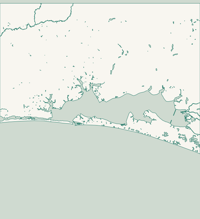
Choose a label to open local resources →Tap a community on the map or below ↗
Land and water: U.S. Census Bureau TIGERweb, 2026. Reference points: USGS GNIS, NOAA CO-OPS and Okaloosa County GIS. General orientation only; not a survey, flood map or service boundary.
Your local starting point
Find your community.
Choose a guide for local maps, permit starting points and the records to gather for your property.
Holiday Isle is a narrow spit inside Destin city limits with three different shorelines. Its Gulf side, home to Sandpiper Cove, is a rebuilt beach in a stretch FDEP lists as critically eroded. On the East Pass side, the new state park parcel is armored with seawalls. Norriego Point, at the tip, drew more than $13 million in restoration money. The harbor side is a busy working waterfront served by a 100-foot Army Corps channel that tens of thousands of boats use each year.
Joe's Bayou is a residential bayou in Destin, home to the city's public boat launch and the Mattie Kelly Nature Walk. Destin's code lists it as a protected zone, so no seawall may be placed in coastal marsh. A $12.2 million restoration plan for the launch area includes a living shoreline and saltmarsh. One city outfall there drains more than 200 lots, which makes stormwater part of most wall problems.
Federal maps class Indian Bayou as a stream, not a bay like nearby Joe's Bayou. County planning layers put its west bank inside Destin and the Kelly Plantation shore to the east in unincorporated Okaloosa County. Neighbors who face each other across the water file with different governments under different rules. Destin's own building office is on Indian Bayou Trail.
A county-side checklist for Kelly Plantation and Regatta Bay
Kelly Plantation and Regatta Bay have Destin mailing addresses, yet county GIS and the Census place them in unincorporated Okaloosa County under county MU-2 zoning. Their bay frontage faces open Choctawhatchee Bay, which runs more than 30 miles long and 4 to 6 miles wide. Jones Bayou cuts into the shore beside Kelly Plantation. Even the inland golf club addresses map to evacuation Zone C.
Crystal Beach sits inside Destin city limits on the Gulf, east of Henderson Beach State Park and its dunes up to 30 feet high. On this shore a seawall counts as coastal armoring under the state Coastal Construction Control Line. Destin bans armoring in its Gulf shoreline zone unless FDEP has issued a permit. FDEP lists 2.1 miles of east Destin beach as critically eroded.
Okaloosa Island runs under 1955 covenants that still apply whether a lot is leased or owned outright. Homes in residential blocks 4 through 9 back onto Santa Rosa Sound, where the Intracoastal Waterway passes Little Marler Park. On the Choctawhatchee Bay side, the county finished 2,000 feet of living shoreline at Veterans and Ross Marler parks in February 2026. Eglin Air Force Base land borders the developed strip, including nearly 4 miles of shore between it and East Pass.
Fort Walton Beach fronts three kinds of water. Downtown faces Santa Rosa Sound, and Garniers Beach faces Choctawhatchee Bay. The Cinco Bayou edge runs along Yacht Club Drive. Normal tide on the sound here is only about half a foot, so wind, rain and storms move the water more than the moon does. The US 98 bridge in town is the line where two federal Gulf sturgeon habitat units meet. At the city's own Landing park, the state permit for a new seawall came in 2018, but the Army Corps permit took until 2022.
The Town of Cinco Bayou covers less than a fifth of a square mile of land. Ocean City and Wright, next door, are census places with no city government of their own. Part of Yacht Club Drive belongs to Fort Walton Beach. Neighbors on one small bayou can answer to three different governments. On nearby Garnier Bayou, almost the entire back half is undeveloped Eglin Air Force Base land.
Okaloosa County runs its main permit office from Eglin Parkway in Shalimar, yet the Town of Shalimar covers less than a third of a square mile of land. Lake Lorraine, next door, is an unincorporated census place with no local government of its own. The shoreline mixes open bay frontage at Meigs Park with the sheltered water of Poquito Bayou. During Hurricane Michael in 2018, a federal sensor at Shalimar logged about 2.7 feet of water over the ground. The storm came ashore far to the east.
Mary Esther's marine code is written for one body of water, Santa Rosa Sound. The normal tide here runs close to a foot, well above the half foot measured at Fort Walton Beach next door. City Council approves seawall and dock permits twice: once before anything else, and again after the state and federal permits. Since August 24, 2026, building permits go through the city's GovWell system, with plan review and inspections by a private firm.
Niceville writes its bayous into its code by name: Boggy, Rocky and Shirks. The city runs its own building department on Partin Drive, and its online permit portal is still listed as coming soon. Niceville does not treat a seawall as an accessory structure, so a lot owner can permit a new or replacement wall before a house. The Land Development Code is being rewritten, with adoption hearings set for early 2027.
Rocky Bayou east of the State Road 20 bridge is the only aquatic preserve in Okaloosa County, and an Outstanding Florida Water since 1979. That one line on the map changes the rules for docks and seawalls along its shore. Bluewater Bay is unincorporated, so its owners get building permits from Okaloosa County, while lots inside Niceville use the city's code. The state's own park plan says boat wakes are undercutting Rocky Bayou's bluffs.
Valparaiso rewrote its waterways code in October 2024, and it names three bayous: Boggy, Weekley and Toms. One rule matters most after a storm. A damaged dock or wall can come back at its old size or smaller only if the city permit is applied for within six months. The same code bars boat wakes that damage seawalls. All of Weekley Bayou inside the city is a no-wake area.
Before you ask for a bay bulkhead in Miramar Beach
Miramar Beach is a census designated place, not a city, so bulkhead and dock permits run through unincorporated Walton County, not Destin City Hall. A Destin mailing address is common here: DBPR counts 87 Walton County condominium projects with a Destin address. On the bay, NOAA's historic Driftwood Point tide station shows a range of only about half a foot. That means wind and storms, not tides, bring most high water.
Santa Rosa Beach has two waterfronts, and this guide covers the bay side. That means Hogtown Bayou, Point Washington and the shore near the US-331 bridge. Near the bridge, Thomas Pilcher Park has four boat ramps and a 380-foot fishing pier. NOAA's historic Hogtown Bayou tide station shows a range of about half a foot. The 30A dune lakes have their own guide.
Freeport has two separate planning offices. The city's Planning & Zoning office handles parcels inside city limits, and Walton County Planning handles everything outside, even with a Freeport address. A 'City of Freeport' line on the tax bill settles it. Either way, Walton County issues the building permit. LaGrange Bayou's historic NOAA tide station shows a range of about half a foot.
Choctaw Beach sits on the north shore of Choctawhatchee Bay along State Highway 20. The shoreline mixes private lots, the county's Choctaw Beach Park and Eglin Air Force Base land at Basin Bayou East. Many addresses say Freeport, but that does not mean city limits. The bay here is 4 to 6 miles wide, and the Basin Bayou tide range is under half a foot.
Dune lake lot checklist: what to do instead of a wall
Walton County counts 15 named coastal dune lakes along 26 miles of its Gulf coast, including Western Lake, Eastern Lake and Lake Powell. Each connects to the Gulf only now and then, through an outfall that acts as flood control. The water ranges from fresh to quite salty. Because hard armoring is banned near these lakes, planning here is about docks, buffers and lake levels.